Project Background
-
What is the relationship between bicycling for recreation vs. transportation?
-
Is recreational bicycling included on the VTrans Bicycle Corridor Priority Map?
-
Does the Strava application work in rural areas with spotty or no cell service?
-
What was meant by ‘Desirability’ on the VTrans Bicycle Corridor Priority Map?
-
How did VTrans handle frequent changes in bicycle ‘use’ along a corridor?
-
How does population factor into decisions about bicycle corridor priority?
-
How is safety included in the decision-making and the methodology?
-
Does the On-Road Bicycle Plan include all Vermont roads?
No. The information we are collecting is focused on State-managed roads and segments of town highways that function as an extension of State roads (also known as Class 1 Town Highways). Some state-managed roads that are limited access were included such as VT- 289 and the St. Albans State Highway because a suitable adjacent alternative bicycle facility does not exist in those locations.
-
How will VTrans deal with Class 1 Road/municipal decisions?
The data collected for this project includes Class 1 Town Highways (those road segments of town highways functioning as an extension of State roads) as part of Phase 1 methodology. This information is available to municipalities for their use and will be consulted during Class Town 1 Highways projects.
-
What is meant by current and potential bicycle use?
- Current Use
- where cyclists are riding now
- Potential Use
- where cyclists would ride if conditions were improved
- where cyclists have greatest potential to ride given land use patterns
- Current Use
-
How will the VTrans Bicycle Corridor Priority Map be used?
The VTrans Bicycle Corridor Priority Map (formerly called the Draft Desirability Map) is the culmination of Phase 1 and will be used to help prioritize improvements and maintenance activities by VTrans on state roads. The high-, moderate- and low-use corridors on the map represent state roads based on an analysis of current and potential bicycle use. A high-use corridor is a higher priority corridor for improvements. The map will also be used to inform future phases of the project (see future phases description in FAQ #2).
It is important to note, VTrans will continue to incorporate bicycle-friendly improvements in all projects and maintenance activities however, high use corridors defines where VTrans will focus efforts.
-
How was the VTrans Bicycle Corridor Priority Map Created?
The VTrans Bicycle Corridor Priority Map shows current and potential bicycle use on state roads. Bicycle use was quantified through analysis of land use patterns, bicycle access to state roads, proximity to destinations, data collected on recreational bicycling, and 2,100+ users providing public input through the project’s interactive crowdsourcing map (aka WikiMap*).
*The interactive crowdsourcing map is part of the development of the VTrans On Road Bicycle Plan. VTrans used this crowdsourcing tool to gather information from the public about current and potential bicycle use. This was captured by asking users to select a line type when mapping a ride. The line types included:
- State Road I like to Bike
- State Road I bike but could be improved
- State road I’d like to use, but needs improvement
-
What is the relationship between bicycling for recreation vs. transportation?
Transportation and recreation are different bicycle trip purposes and are equally important measures in determining current and potential bicycle use of a roadway.
Transportation refers to the dominant purpose of a trip being utilitarian, such as doing errands, commuting to work or school, or visiting a friend.
Recreation refers to the dominant purpose of a bicycling trip being for exercise or enjoyment of the outdoors.
There is much crossover between transportation and recreation bicycling, sometimes even on a single ride. However, we distinguish the two because travel behavior, preferred routes, and appropriate facility types can be different.
-
Is recreational bicycling included on the VTrans Bicycle Corridor Priority Map?
Yes.
VTrans captured recreational riding using both Strava data and the interactive crowdsourcing map (aka Wikimap).
Strava Metro is a mobile application used by bicyclists to track recreational and transportation bicycling trips.
WikiMap is an interactive crowdsourcing map to crowdsource information from the public about current and potential bicycle use.
-
Does the Strava application work in rural areas with spotty or no cell service?
Yes. Strava relies on GPS (global positioning systems), which works worldwide regardless of cellular service.
-
Are transportation bicycling (commuter/utilitarian) trips included in the VTrans Bicycle Corridor Priority Map?
Yes.
VTrans captured transportation bicycling trips through the interactive crowdsourcing map (aka WikiMap) and by analyzing land use patterns, bicycle access to state roads, and proximity to destinations.
-
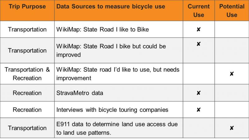
What was meant by ‘Desirability’ on the VTrans Bicycle Corridor Priority Map?
The term ‘desirability’ was intended to describe the potential and current bicycle use on state roads: where people ride and where they would ride if conditions were improved. To clarify the purpose of the map, VTrans will now use the term ‘use’ rather than ‘desirability’ to indicate current and potential bicycle use.
Current and potential bicycle use along corridors was determined by the following data sources:
-
How did VTrans handle frequent changes in bicycle ‘use’ along a corridor?
Due to the nature of the raw data source and the scoring methodology used to determine bicycle use, some sections along a road segments/corridors needing smoothing. VTrans undertook a smoothing exercise to introduce consistency in a corridor where appropriate. The “smoothing” exercise used our with and experience managing state roads along with the following considerations:
- Blend very small segments with adjacent segments
- Use logical connections or terminus
- intersections with major state or local roads
- roads known to be a suitable alternative to a state route
- roads known as a popular route with bicyclist
- Significant land use changes
- Municipal boundary or City limits
- existing school or recreation area, etc.
- Resort or significant trip generators
- tourist destinations
- four season resort
- International or State border crossings
- Designated Scenic Byway, Rail Trail or existing signed bicycle route
-
How does population factor into decisions about bicycle corridor priority?
Because VTrans methodology relied on land use patterns, population inherently affects the potential use of state roads for bicycles.
In response to concerns that density was favored in the methodology, we refined our scoring system so the maximum number of points a segment could receive from land use pattern-based riding and from recreation riding are the same.
-
How is safety included in the decision-making and the methodology?
Safety is very important to VTrans, and the overarching goal of this project is to ensure safer roads for all users.
We implicitly received safety information in Phase 1 using the interactive crowdsourcing map by asking users to draw lines on state roads they “would like to use but need improvement.” See FAQ #2 for interactive crowdsourcing map input.
Future phases will include an analysis of reported bicycle crashes and examine the safety data entered in the Phase 1 interactive crowdsourcing map (aka Wikimap).