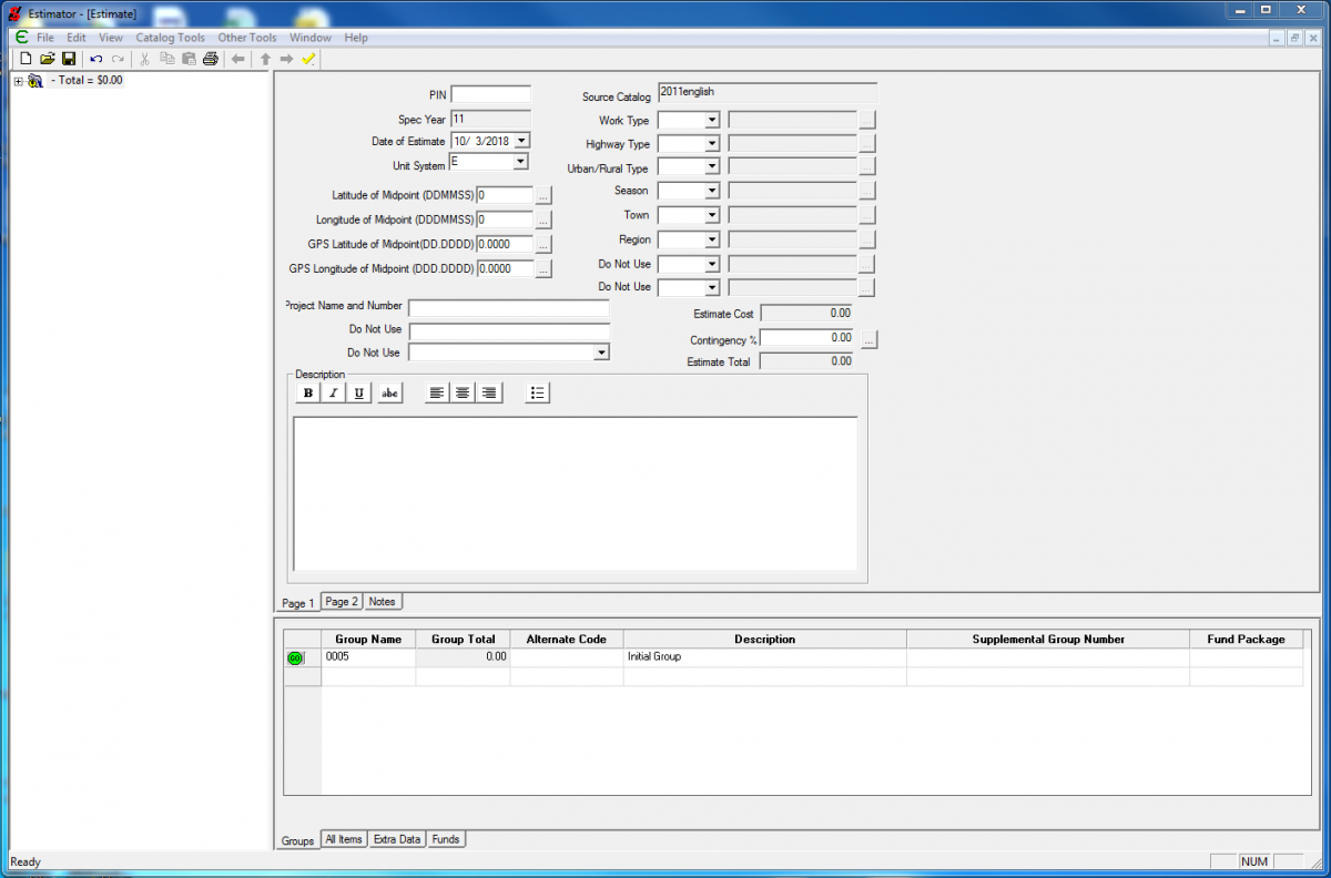
This is a listing of the data fields that appear on the main window in Estimator® (project level). The field name is followed by an explanation of the appropriate data that should be entered into that field. For reference, the list is followed by a screen print of the main window page. This guidance should be followed when creating or updating an estimate.
** Note: All Data entered in Estimator needs to be done in UPPERCASE LETTERS **
PIN (or Estimate ID): This field is the PPMS Project Identification number (PIN).
Spec Year: This field is locked based on the catalog selected.
Date of Estimate (or Base Date): This is the date that the estimate is being prepared (if a template is being used this field will already be populated but will need to be updated).
Unit System: This field is locked based on the catalog selected.
Latitude of Midpoint (DDMMSS):
Longitude of midpoint (DDMMSS): This is the latitude and longitude at the midpoint of the project. Available sources include Google Earth or GIS as well as other places. If there are multiple sites to the project use the site that has the greatest monetary impact on the project. If these fields are used the latitude (DD.DDDD) and longitude (DD.DDDD) fields are autopopulated.
Latitude of Midpoint (DD.DDDD):
Longitude of midpoint (DD.DDDD): This is the latitude and longitude at the midpoint of the project. Available sources include Google Earth or GIS as well as other places. If there are multiple sites to the project use the site that has the greatest monetary impact on the project. If these fields are used the latitude (DDMMSS) and longitude (DDMMSS) fields are autopopulated.
Project Name and Number (or Federal Project Number): This field is the project name and number shown within the corner block of our plan sheets. The field as designed within Estimator has a limitation of 30 characters maximum which may result in the need to abbreviate. If abbreviation is required, it should be done in a manner which will not compromise the integrity/identity of the project name but more importantly the project number. Additoanlly the first town in the name should not be abbreviated.
As an example WALLINGFORD - RUTLAND TOWN NH 2408(1)S can be abbreviated as WALLINGFORD-RLDTWN NH 2408(1)S
Description: The intent of this field is to use the same work description included on the project plans title sheet. However, this field has a limitation of 120 characters maximum so it may not be possible to include this full description. If the full description does not fit within the 120 characters, a shortened work description can be used to provide information within the estimate and on the cover sheet of the printed estimate to give a sense of the project scope. Common ways to shorten the description include omitting phrases such as "the work consists of" and by listing work using commas instead of words like "and," "including," or "with."
Source Catalog: This is the name of the catalog being used to price the estimate. field is locked based on the catalog selected.
Work Type: Select the work type that best fits the project from the drop down list. If unsure of what to use ask for guidance.
Highway Type: Select the correct Functional Classification for the project from the drop down list. If unsure of what to use ask for guidance.
Urban/Rural Type: Select the urban or rural condition for your project. There are no firm criteria for this. Guidelines include: Is the project located in a federal aid urban compact? Or, is there curbing and sidewalk? To some extent this will be based on sound judgment.
Season: Select the season that the project is expected to be bid in from the drop down list.
Town (or County): Select the TOWN that a project is located in from the drop down list. If the project is in multiple towns use the town with the largest percentage of the work
Region (or District): This is the Construction region as defined by the Construction and Materials Bureau that the project is located in. (SW, SE, NE, or NW.) This is NOT the operations (maintenance) district number.
Estimate cost: This field is automatically calculated as the sum of the included items. It cannot be changed.
Contingency %: This field should be left as zero. The Agency uses other methods to track the contingency at each estimate level. Including a contingency here leads to a double counting of contingency costs.
Estimate Total: This is the sum of the estimate cost and any additional added by the contingency %. It cannot be changed.
For a complete listing of the data required or information available on all of the tabs in Estimator® at the project level, download the Estimator project data fields guidance file located in the menu on the left.