Introduction
The Vermont Transportation Resilience Planning Tool (TRPT) is a web-based application that identifies bridges, culverts, and road embankments that are vulnerable to damage from floods, estimates risk based on the vulnerability, and criticality of roadway segments, and identifies potential mitigation measures based on the factors driving the vulnerability.
The TRPT combines river science, hydraulics and transportation planning methods and is applied at a watershed scale. The TRPT has been developed for the entire state and is ready to be applied to inform project scoping, capital programming, and hazard mitigation planning for state and local highways. The TRPT informs the resilience criterion in the VTrans Project Selection and Prioritization Process (VPSP2) which is used to select new VTrans Capital Program projects
TRPT Trainings
VTrans, in coordination with its consultant team, conducted statewide trainings to coincide with the completion of the TRPT. The training series has ended but the training materials linked below are intended to help educate a wide variety of users including municipal staff, project designers, professional planners, state agency staff, and other regional and non-profit organizations.
Training videos: A series of videos are available to guide users through the TRPT.
- The Introduction video introduces the app, the motivations behind its creation, and the underlying concepts.
- The Web App Overview video walks through the functionality of the app and how to navigate it.
- The Local Bridge Planning Example video and State Highway video take a deeper dive into the app using two example locations.
- Finally, the Case Studies video uses the same two locations to demonstrate how the TRPT translates and conveys conditions on the ground and can be used to screen and prioritize projects.
Training slides: The training series has ended, but the slides from the trainings are available to review.
Quick Links
TRPT Web Application
TRPT User Guide
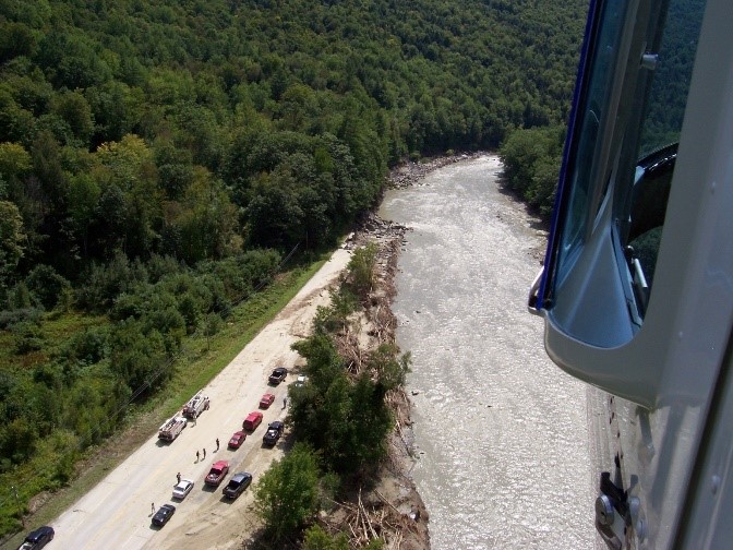
This section of VT-107 was severely damaged by Tropical Storm Irene. The TRPT identifies and prioritizes high risk locations before damage occurs.
Purpose
The need for the TRPT became apparent following the widespread damage and destruction to state and local roadways caused by Tropical Storm Irene in August 2011, and due to the increase in ongoing local damages that take place each year. Much of the Agency's effort following Tropical Storm Irene focused on improving its emergency response and recovery capabilities to restore transportation functionality faster after a disaster. The TRPT's purpose is to identify vulnerabilities in a proactive manner to avoid or mitigate against the impacts of future damages in the most critical, highest risk locations.
TRPT Development
The TRPT was developed by VTrans with funding from the FEMA Hazard Mitigation Grant Program (which also funded the 2018 Vermont State Hazard Mitigation Plan update), federal transportation planning funds, and match from state transportation dollars.
A multi-disciplinary consultant team led by Milone and MacBroom, Inc. (now SLR) was selected to create the underlying vulnerability, critically, and mitigation identification methods and to develop the web-based application. Partners and stakeholders included several regional planning commissions, municipalities, and watershed groups, the Vermont Agency of Natural Resources, Vermont Emergency Management, Agency of Commerce and Community Development, and University of Vermont.
TRPT Users
The TRPT can be used by anyone with an interest in planning to identify and prioritize vulnerable locations and to create a list of potential solutions. It runs on a map service that is easy and intuitive to navigate and interpret and allows users to evaluate scenarios for three different storm events. The TRPT was designed for users that range from engineers and planners to the local volunteers that are the backbone of Vermont's municipal governments, planning commissions, conservation commissions, and emergency management.
TRPT User Guide
The User Guide describes the concepts and key assumptions underlying the TRPT to help users understand the origin of the data and how to interpret results. It explains how to navigate the online TRPT Web Application and provides case study examples from the three pilot watersheds.
GIS, river science and engineering, and transportation planning skills are required to build the TRPT for each watershed. Detailed descriptions of these methods and tools are also provided in the User Manual and are intended for use by the technical professionals that will add more watersheds in the future.
QUESTIONS
Andrea Wright
Environmental Policy Manager
Vermont Agency of Transportation
Email: Andrea.Wright@vermont.gov
Phone: (802) 917-1586
NEWSLETTER SIGN UP
If you would like to receive updates from the Agency of Transportation about climate programs and initiatives, please subscribe to our newsletter.