INSTRUCTIONS FOR COMPLETING PAGE 1
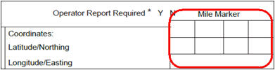
COORDINATES SECTION
17. Coordinates - This field may be used by departments that have GPS technology. GPS is an acronym which stands for Global Positioning System. GPS technology provides latitude and longitude readings that can be converted to a more defined roadway location.
Submission of paper crash reports:
If you are a law enforcement agency that continues to submit paper crash reports, then you need to report VT State Plane coordinates (metric).
When submitting the crash report electronically via Web Crash:
When submitting crash reports electronically, you will have a choice of submitting Lat/Long or VT State Plane coordinates. You will need to identify the datum and format of the coordinates being provided. There are two options for coordinate format/datums for those law enforcement agencies submitting crash reports electronically. They are:
Lat/Long NAD1983
VT State Plane (metric) NAD1983
GPS may be reported in either Vermont State Plane (metric, NAD1983) or in Latitude and Longitude (in the format of xx.xxxxx degrees, NAD1983.)
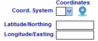
The Web Crash application has a “Map” tool for obtaining GPS coordinates and automatically populating the coordinate fields in the form. It is found on page 1 adjacent to the Coord.System field. (See below.) Instructions for use of the Map feature can be found in Appendix G. This tool can be used to obtain GPS coordinates without the need of field collection as long as sufficient location reference information (roadway intersections, driveways, etc.) can be determined using the tool.
NOTE: When submitting electronically, be sure to identify the format/datum of the coordinates being reported. If the coordinates are mis-identified, then the data is of no use for location purposes.
When using the Map tool, the Coord.System is populated automatically.
The map feature was updated to allow law enforcement to auto-fill many of the location boxes based on the marker location.
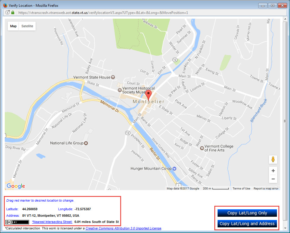
Once you have the marker where you want it, the “Address” line should be close to or at the location of the crash, to include the city/town. The “Nearest Intersecting Street” is also available. To copy all of the address and GPS coordinates, use the “Copy Lat/Long and Address” button. If you do not want to auto-fill the address, use the “Copy Lat/Long Only” button.
Law enforcement who have GPS units that were provided by the Vermont Agency of Transportation and use them to report crash location coordinates on the crash report form should also continue to report the traditional text location description: City, Town, Street Address, TH#__/VT#__/US#__/I-+__, Intersection with OR Nearest Intersecting St. or Landmark, Distance, and N/S/E/W.
If a crash occurred where the vehicles came to rest on the highway, the GPS readings should be taken at the crash location as described in the “Crash Location” section of this manual. If, however, the vehicle(s) came to rest outside of the highway right-of-way (for example, off the road some where in a field), then GPS readings should be taken at the point on the highway shoulder where the vehicle left the highway.
At no time should officers place data collection of GPS over their own safety. If it is unsafe for an officer to take a GPS reading of a crash location, then the reading may be taken on the shoulder directly across from where the crash occurred on the highway. An example is that a crash occurred in the middle of a high traffic intersection. If the officer determines that it is impossible or unsafe to obtain a GPS reading in the intersection, a reading from the shoulder directly across from the intersection will suffice.
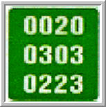
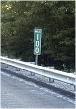
18. Mile Marker - Several years ago, the Agency of Transportation installed mile markers on all routes within its jurisdiction (such as US, Vermont, and other local Federal Aid eligible highways). An example of the green mile marker for those routes listed above (not including the Interstate highway system) is shown below.
If the route has mile markers, insert the mile marker information within the appropriate block area.
1st Row Route number should be entered here.
2nd Row County/town code should be entered here.
3rd Row Enter mileage distance to a town line or mileage distance to the beginning of the route, if a four lane divided highway.
Example: On the mile marker shown above, the first line “0020" is the route (US-2), the second line “0303" is the town code (Danville), and the last line is the town mile marker 2.23. The mileage is the mileage from the town line based on VAOT mile marker system. The numbers 0020 should be entered in the first row, 0303 should be entered in the second row, and 0223 should be written in the third row.
Example of route numbers and coding for the first line:
VT-244 2440
VT-100 C 100C
I-89 0890
US-2 0020
Please Note:
On the Interstate highway system, there are two variations of the mile marker signs. One is the vertical, full mile marker and the other sign uses two rows of numbers.
The sign above notes the whole mile location on the highway.
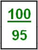
In this sign, the top number represents the full mile, and the bottom number represents mileage in hundredths of a mile (0.xx). In the example above, the location of this sign is at mile marker 100.95.